DITS operation manual
What is DITS ?
Twitter is a powerful tool for sharing various information including damages of local areas at the time of disasters.
DITS (Disaster Information Tweeting System) is an app that helps you post and share the damage situation on Twitter in the event of a disaster. According to your current location, a hashtag "# ◯◯ city disaster" will be automatically inserted in the tweet.
At the same time, a code that represents the current address and location information called UTM points is also inserted. This makes it easier for others to understand where you are. If you need help, you may also add the hashtag "#Rescue".
Notes
- A Twitter account is required to use DITS. If you donʼt have a Twitter account, please visit https://twitter.com/signup and get an account in advance.
- Please allow the use of location information in the browser you use. Then, the address of your currentlocation will be automatically added to the tweets you post with DITS. This will allow others to know where you are. So, please be careful when doing so.
- If the file size of the attached image is too large, posting the tweet may fail.
- DITS assumes the use of terminals equipped with GPS functions such as smartphones. There is a possibility that location information cannot be appropriately obtained when using DITS from a PC.
- Your current location may not be appropriately acquired if you are indoors.
- When posting tweets, keep your safety first and keep away from a dangerous place.
- Please follow the rules of Twitter, Inc. regarding the use of Twitter. Please mind paying sufficientattention to the handling of personal information when taking pictures and posting tweets.
- If you need a rescue, try to contact the relevant organizations first. Use DITS as one of your second choices.
- DITS cannot be used with feature phones.
How to use DITS
Please access with a web browser. (chrome, Firefox)
https://glocal-dits.u-tokai.ac.jp
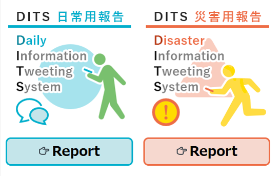
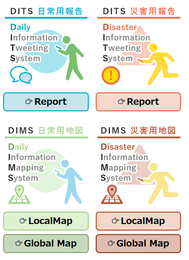
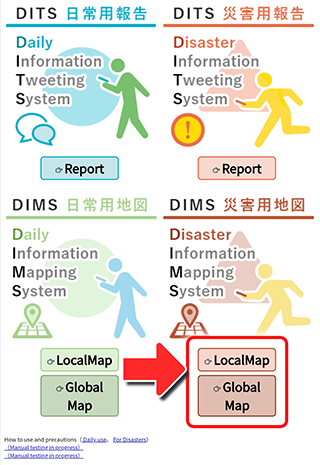
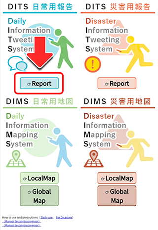
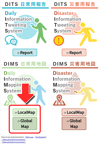
「DITS: Daily Report」
You can post and share information on your daily life, such as shopping, dining, sightseeing, etc.「DIMS: Daily Map」
You can check the information posted via "DITS Daily Report" on a map. You can select either "Local Map" which displays information around your current location (obtained from GPS) or "National Map" which displays information in a wide area.「DITS: Disaster Report」
You can post and share damage reports and rescue requests in case of a disaster.「DIMS: Disaster Map」
You can check the information posted via "DITS Disaster Report" on a map. You can select either the “Local Map" that displays information around your current location (obtained from GPS) or "National Map" that displays information in for a wide area.Disaster
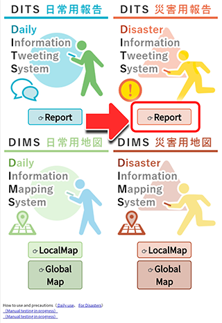
Click "Report" to switch screens.
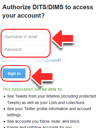
Enter your Twitter ID and password in the username and
password fields respectively, and press the "Login" button.
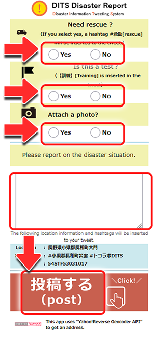
Select "Yes" or "No" depending on the situation.
If you select "Yes" for "Need rescure?", the hashtag "#rescue" will be inserted.
[Attach photo?] If you selected "Yes" in the field, select an existing photo in your device.
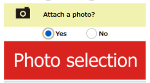
(The photo selection process may vary depending on the model of your mobile phone or tablet.)
Check the input items and click "Post" at the end.
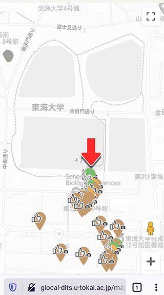
"DIMS: Disaster Map"
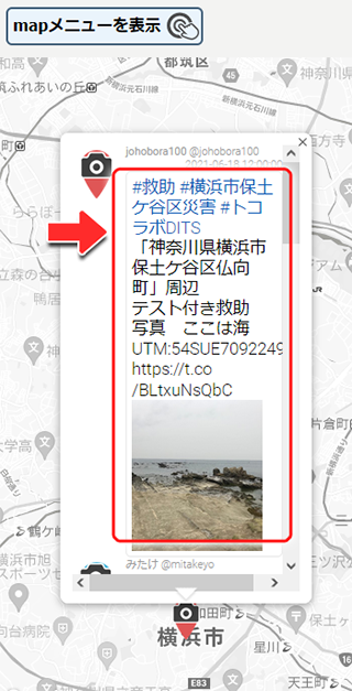
The location of each tweet posted via "DITS Disaster Report" will be displayed on the map.
"Local map"
The location of each tweet posted around your current location (obtained from GPS) will be displayed on the map.
"National map"
The location of each tweet posted at wider area will be displayed on the map.
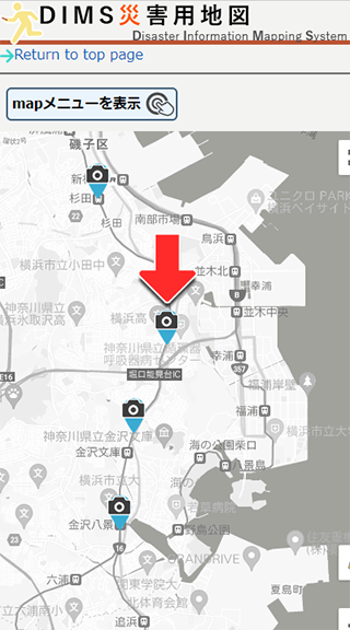
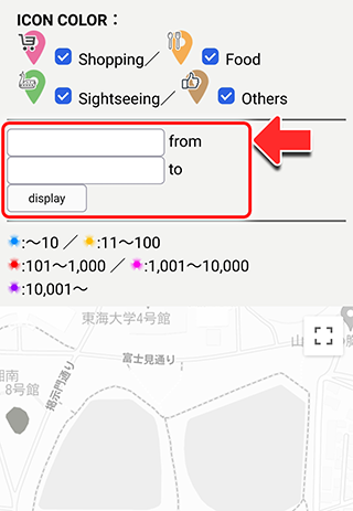
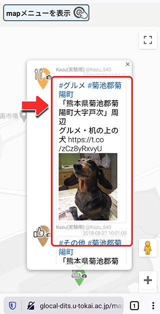
By clicking the markers, you can view the posted tweets.
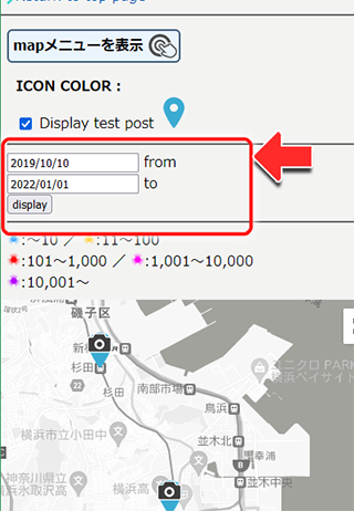
You can specify the period for searching the tweets.
The posted tweets can be viewed on the map.
Daily
Click on “Report” to make a report. The screen will be changed report window.

Enter your Twitter ID and password in the username and password fields, respectively, and press the "Login" button.
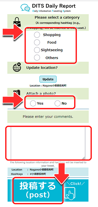
Select the items you wish to report.
The location information is automatically imported.
[Attach photo?] If you selected "Yes" in the field,
select an existing photo in your device. (The photo selection process may vary depending on the model of your phone or tablet.)
Check the input items and click "Post" at the end.
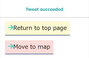
If the tweet posting is successful, the screen will be switched to the "Tweet succeeded" screen. Select "Return to top page" or “Move to map".
The posted content will also be posted to your Twitter account timeline.
"DIMS Daily Information Map"
The location of each tweet reported with the Daily Information Tweeting System will be displayed on the map.
"Local map"
Location of each tweet posted at around your current location (obtained from GPS) will be displayed on the map.
"National map"
Location of each tweet tweeted at wider area will be displayed on the map.
By clicking the markers, you can view the posted tweets.
You can specify the period for searching the tweets.
The posted tweets can be viewed on the map.
→Return to DITS